 |
| Tonight's winds |
Fellow Illinoisans!
For those of you still up, let's take a look at what's over our heads tonight. Most important are the east/southeasterly
winds over Southern and Central Illinois. These winds are more conducive to migration than what's happening in Northern Illinois, as we'll see, but fear not about reduced migration. Let's divvy Illinois up by Northern, Central, and Southern regions (Central and Southern IL will be grouped) to analyze the complexities of tonight's winds, weather, and migration:
 |
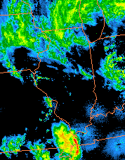
| Tonight's radar |
NORTHERN ILLINOIS:
Tonight, a
low pressure system has been rotating a little faster than expected, bringing a cold front southward over Northern Illinois like a curtain closing a play. This curtain is composed of northeasterly winds, propelled downward by the aforementioned cold front. SO, if we look at those conditions that tend to be favorable for migration, seeing anything "north" in the winds is generally not a good thing. But tonight, birds are persevering through the Prairie State with remarkable consistency. Northern Illinois is host to
the same light to moderate concentrations of migration that are seen in Central and Southern Illinois. On the
radar, this is resulting in a remarkably consistent blue stain over Illinois, with black patches only visible in the wake of oncoming storm systems. What does all this mean? It means that tomorrow morning, if you can get out before the rain, you should observe some notable arrivals and influxes.
 |
Winds forecast for
Sunday night |
Well that's good news! Looking ahead, Sunday night may also be favorable for migration throughout the state, though in many places it may be disrupted by precipitation. With the approach of a low pressure center, winds will be weakly southerly throughout the state until around 10 AM on Monday. From there, the
wind forecast puts our next batch of southerly winds on Tuesday night. Until then, I'll keep you posted.
CENTRAL & SOUTHERN ILLINOIS:
Tonight, the story is relatively simpler in Central and Southern Illinois. Winds there are consistently southeasterly. Resulting from these consistent winds is consistent migration, forming concentrations aloft in the light to moderate range (~59-227 birds per cubic kilometer of sky; radar
here). This means the same thing it has meant for the past few days now: arrivals and influxes. Though these past few days have reportedly been exciting times to bird, it will be interesting to see if there's an added vigor to tomorrow morning's migrants as they rush (in groups) to find resources before the onset of precipitation. Keep an eye on the radar; if you are in an area where storm activity is set to hit shortly before sunrise, migratory fallout is likely.
 |
| Winds forecast for Tuesday night |
Looking now to the
forecast, Sunday night is set to be favorable for migration throughout the state, though in many places it may be disrupted by precipitation. With the approach of a low pressure center, winds will be weakly southerly throughout the state until around 10 AM on Monday. From there, the wind forecast puts our next batch of southerly winds on Tuesday night. Until then, I'll keep you posted.
~
Overall, regardless of where you are, arrivals and influxes should be pretty consistently noteworthy tomorrow, so if you can, get out there tomorrow! An interesting behavioral note: with oncoming storm activity and other natural stressors, migrants are generally much more social in areas they've just arrived to. They do this because following other migrants is a good way to find food and shelter when they don't have time to find it for themselves. So what does this mean for our birding? It means that migrants may be especially congregated between bouts of precipitation tomorrow, and some exciting mixed feeding flocks may be out there for the finding. What might be in those flocks? Click
here to predict what you'll find.
With that, I'll bid you all ado for the night. Good luck in your birding tomorrow!


