 |
| Westerly winds throughout most of the state |
 |
| Light Migration in NE IL |
For those of you looking forward to the weekend, it doesn't look too much more promising. Leading up to Saturday, the low-pressure system will pass by to the north of us, and the cold front and following westerly winds will dominate the state. Tomorrow should be windy, overcast, and cold because of this. It's not likely that heavy concentrations of birds will be migrating tomorrow night, let alone during the day. Birders should keep an eye out for raptors and other day migrants or even western vagrants nonetheless, but seeing as the cloudy skies won't produce many thermals, raptor migration at least may well be kept to a minimum. Tomorrow will be a sit-tight and fatten-up day for migrants. Saturday may be a bit better. The cold front and westerly winds are forecast to be followed by a period of high pressure dominating the East, and seeing as high pressure systems move sloooowwwlllyyy, the warmer temps, low levels of rain, and weak winds should last about three days starting Friday night or Saturday. After that, as we'll be on the front of clockwise-rotating high pressure system, we'll be having northerly winds in opposition to migration. We should finally get southerly winds, albeit weak ones, late Saturday into Sunday. So it looks like it won't be just one day of sitting tight and fattening up.
So what's around/will be around? In N IL, we seem to have had a few nice movements of Icterids, with the highlights being YELLOW-HEADED BLACKBIRD AND BREWER'S BLACKBIRD. Waterfowl continue to be moving, with BLUE-WINGED TEAL and NORTHERN SHOVELER being super abundant. I maintain my predictions from yesterday (http://bit.ly/114nanz), but rather than posting that again as there probably won't be too many different birds around tomorrow than today, here's a summary of a report from S IL Keith McMullen sent in (remember, they had good conditions for migration last night). It provides a nice summary of the birds moving through and/or into the state soon or come May: PRAIRIE WARBLER, WORM-EATING WARBLER, TENNESSEE WARBLER, SUMMER TANAGER, RED-EYED VIREO, WARBLING VIREO, EASTERN KINGBIRD, GREAT CRESTED FLYCATCHER, BLUE GROSBEAK, ORCHARD ORIOLE, YELLOW WARBLER, HENSLOW'S SPARROW, SOLITARY SANDPIPER, NORTHERN WATERTHRUSH, INDIGO BUNTING, YELLOW-CROWNED NIGHT-HERON, GRASSHOPPER SPARROW, LEAST SANDPIPER, HUDSONIAN GODWIT, WILSON'S PHALAROPE, SNOWY EGRET, SPOTTED SANDPIPER, RUBY-THROATED HUMMINGBIRD, FORSTER'S TERN, WILLET, SORA, LEAST BITTERN, KENTUCKY WARBLER, HOODED WARBLER, BALTIMORE ORIOLE, and PALM WARBLER. Awesome job Keith. I'm drooling.
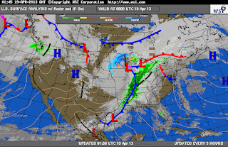 |
Monitoring the fronts is crucial to finding the most migration
That's all for now folks...keep looking!
|
No comments:
Post a Comment